
In the North Atlantic, the tropical system known as Henri reached hurricane status on Saturday, August 21, 2021. At the time, it was approaching a landfall in New England. Between Friday and Sunday, Henri was observed three times by the Dual-frequency Precipitation Radar (DPR) on the core satellite of NASA’s Global Precipitation Measurement (GPM) mission.
The GPM satellite’s first two flyovers of Henri occurred just 10 hours apart and revealed a remarkably unchanging structure that was being impacted by wind shear. A third overflight occurred a day later, when wind shear had abated and Henri had become more organized. The GPM mission’s observations, such as these, are processed in near real-time for use by weather agencies and researchers.
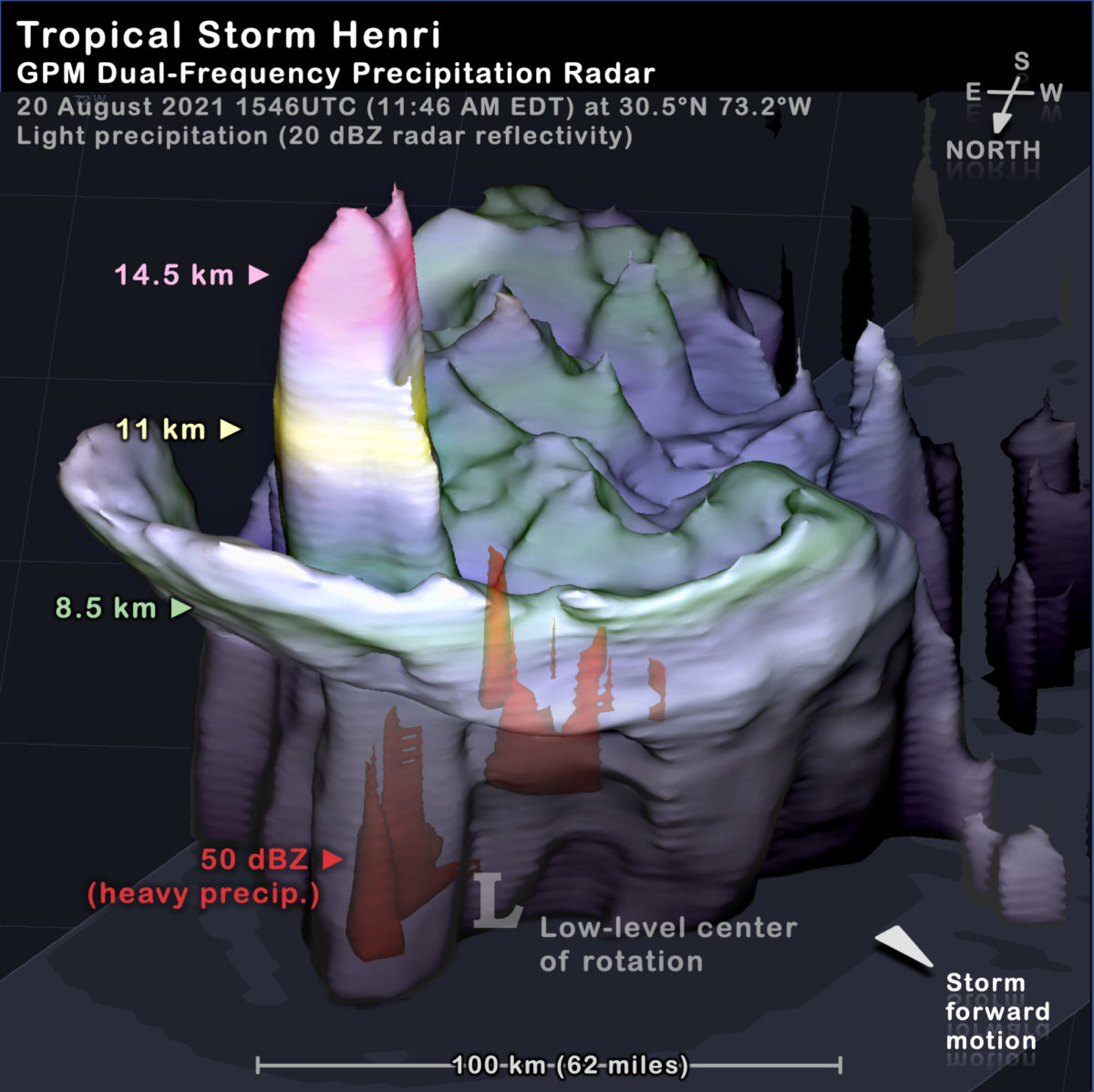
Above, the 3D image from the first overflight shows the volume of light precipitation associated with Henri at 1646 UTC (12:46 PM local time) on Friday (August 20), and the structure tells this chapter of Henri’s story. At this time, Henri’s center was approximately 750 miles south of the Connecticut coast.
Light precipitation is detected by a 20 dBZ radar reflectivity, with color-coded stripes indicating which portion of the precipitation reached an altitude of 8.5 km (green), 11 km (yellow), or 14.5 km (red) above the ocean surface. A letter “L” indicates the location of the system’s low-level center of rotation.
For several days, Henri had been battling strong wind shear. Wind shear is when the horizontal wind near the Earth’s surface is blowing in a different direction or speed than the horizontal wind higher in the troposphere, the layer of the atmosphere that most storms are confined to. Henri’s low-level center of circulation was at its northern edge, with most of the precipitation occurring in a 100-kilometer-wide area to the south of the low-level center of circulation. Wind shear can encourage the formation of strong convective cells in the inner core of a tropical system, but shear can also hamper those convective cell’s ability to strengthen that system.
Hot Towers and Heat Engines
In the first overflight of Henri on Friday morning, a “hot tower” convective cell was observed adjacent to the low-level circulation center, and this hot tower had strong enough updrafts to lift ice precipitation more than 16 kilometers (10 miles) above the ocean’s surface. Hot towers are convective cells with updrafts strong enough to lift precipitation up through the top of the troposphere.
A series of hot towers in the inner core of a tropical storm or hurricane indicates that a considerable amount of heat is being released inside the storm. This heat could result in wind intensification if wind shear or other factors do not short circuit the process.
The second overflight of Henri (not shown) occurred late on Friday night, local time, which was early on Saturday morning in universal time (0232 UTC). At that time, shear was still high and Henri still had a hot tower near its low-level center of rotation. By 11 AM Saturday morning (1500 UTC), shear had weakened and Henri had strengthened 5 knots to becoming a category-1 hurricane according to the National Hurricane Center.
Hurricanes are often said to contain “heat engines” because they convert some of the energy in the sun-warmed surface of the ocean into kinetic energy of the hurricane’s strong winds that rotate around its low-level center of rotation. In this analogy, strong convective cells in the inner core of a hurricane are the pistons of its heat engine.
When a factor such as wind shear inhibits this energy conversion, one might say that all the pistons of the heat engine were firing but the engine wasn’t in gear. In other words, vigorous convective cells were injecting heat into the atmosphere, but the hurricane could not convert that heat into a well defined eye circled by rapid winds. This diagnosis of Henri is consistent with the two GPM satellite overflights during the 10-hour period on Friday, August 20.
Wind Shear Weaken,
Henri Strengthens into a Hurricane

As pictured above, the Dual-frequency Precipitation Radar flew over Henri for a third time late on Saturday night, local time (9:37 PM EDT), which was early Sunday morning in Universal Time (0137 UTC). At this time, Henri’s center was approximately 230 miles south of the Connecticut coast. The precipitation of Henri’s inner core at this time was consistent with that of a weak hurricane. In this overflight, the DPR captured most but not all of the eye. The precipitation along the southwest edge of the eye was outside of the field of view of the DPR.
On Sunday, Henri had an eye, an area at its center that was free from precipitation, and an eyewall, an arc of heavy precipitation around that eye. Henri’s eyewall was relatively weak, with updrafts able to lift precipitation to less than 8 km altitude in most places.
In the Sunday morning overflight, there was, again, a hot tower near Henri’s center. Given time and favorable circumstances, a series of hot towers in a hurricane’s eyewall can lead to intensification, according to NASA research. For Hurricane Henri, further intensification was not forecast, nor did it occur, following this overflight. Further intensification likely did not occur in part because Henri entered cold water off the coast of New England. Credits: Visualization and caption by O. Kelley.