
During July 17 to 28, 2021, several storm systems brought heavy rain to parts of China and surrounding countries, while a nine-month-long drought persists in an adjacent part of China. NASA’s multi-satellite precipitation algorithm has been monitoring this rainfall in near real-time, and the estimates are distributed to weather-forecasting agencies and disaster-monitoring organizations. This algorithm is called IMERG, the Integrated Multi-satellitE Retrievals for GPM. GPM is the NASA / JAXA Global Precipitation Measurement mission, which launched its Core Observatory satellite in 2014.
Two Typhoons
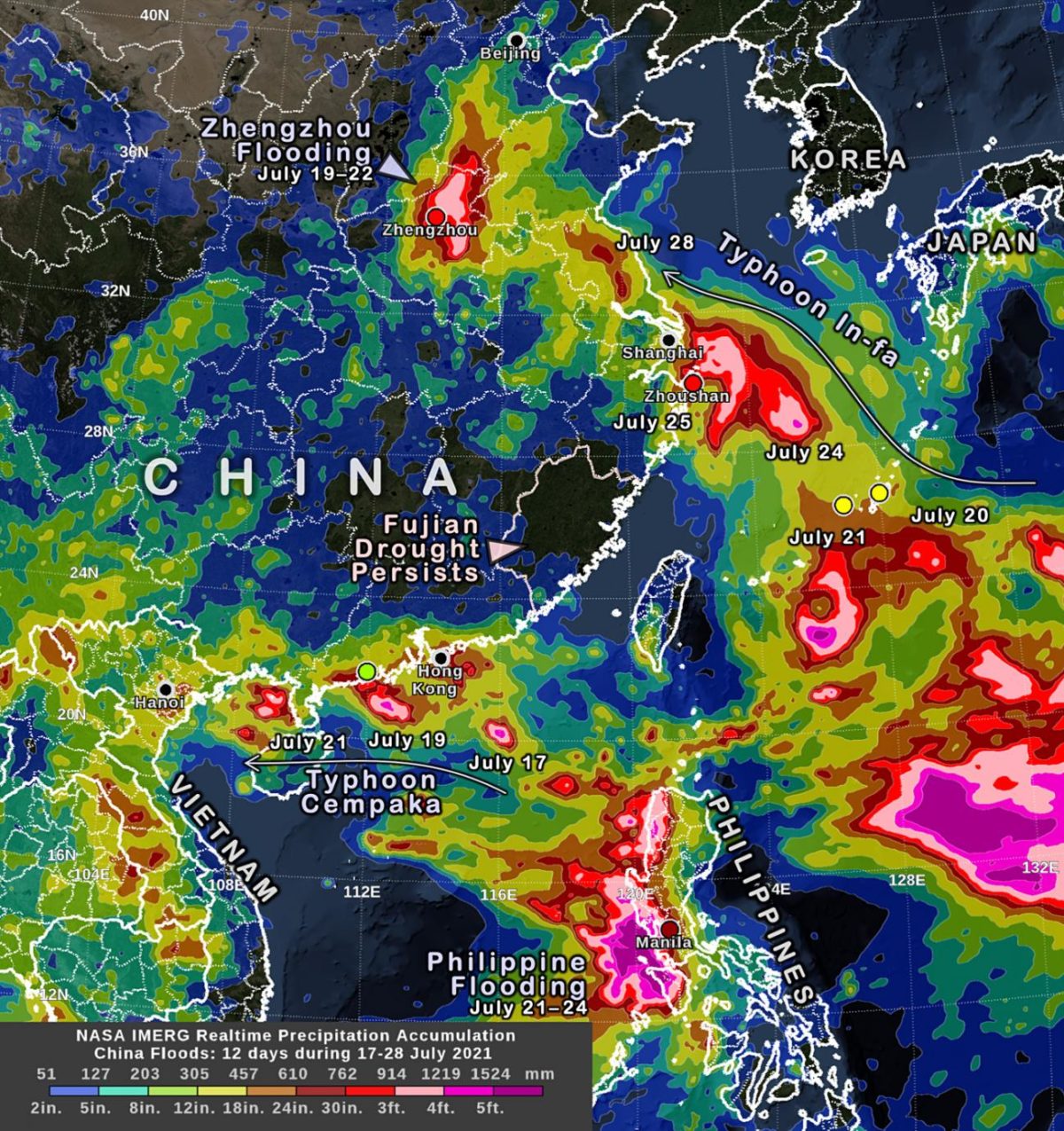
IMERG precipitation estimates from July 17 to 28, 2021, are shown in the image above. Among the weather systems impacting the region were two landfalling typhoons – Cempaka and In-fa.
One can see that over a foot of rain has fallen during this 12 day period along most of the coast from Hong Kong west to Hanoi, Vietnam. This rain came mostly from Typhoon Cempaka during July 17 through 19.
Over a foot of rain has also fallen during this time near Shanghai, which is China’s most populous city. That rain came mostly from Typhoon In-fa during July 25 to 28. According to Buckingham (2021), parts of Zhoushan City, near Shanghai, received at least 30 inches of rain from In-fa between July 23 and 27. Over the Pacific Ocean near China, two rain gauges in the Global Historical Climatology Network (GHCN) reported 12-inch rain accumulations during the July 17 to 28 period at locations where NASA’s IMERG algorithm also reported similar accumulations. These gauges are located on two small islands, Japan’s Nago and Kumejima islands. Point estimates of rainfall are represented in the image as circles that is colored using the same color scale used to display the IMERG data that covers the globe. Nearby over the ocean, where no rain gauges exist, the IMERG algorithm reported significantly more rain accumulation along the path of Typhoon In-fa, over 30 inches of accumulation.
Two Additional Storm Systems
During the same time, a synoptic system brought over 30 inches of rain accumulation to the Chinese city of Zhengzhou and surrounding areas of Henan Province during July 19 to 22. According to Childs (2021), over 31 inches fell during a three-day period.
Also separate from the two typhoons, a storm system brought accumulations in excess of 20 inches to the western coast of the Philippines, near Manila, during July 21 to 24. These accumulations were detected by the IMERG algorithm and are consistent with rain gauge data in Manila.
While such accumulations are impressive, they are not unprecedented. For example, Hurricane Harvey (2017) stalled over Texas and brought over 60 inches of rainfall to a small area over a period of four days (Blake and Zelinsky, 2018). IMERG was also used to analyze the rainfall from Harvey.
A Persistent Drought
Meanwhile, a drought in Fujian Province in coastal China has persisted since October 2020 with rainfall accumulation less than 25% of the typical accumulation for part of Fujian Province. Deviation from normal rainfall can be estimated using the long-term record of IMERG estimates that stretches back to the year 2000.
Wang (2021) and Ye (2021) report that China’s coast south of the Yangtze River, a region that includes Fujian Province, only received 20% to 50% of the normal amount of rainfall between October 2020 and February 2021. IMERG data shows that summer rains have relieved the drought in the provinces adjacent to Fujian, but not in Fujian itself.
The regional rainfall patterns seen during the past two weeks over China are significantly different than the Meiyu-Baiu pattern of rainfall that IMERG detected at this time last year. Credit: Visualization and caption by O. Kelley.