The Global Precipitation Measurement (GPM) mission has released an improved version of a multi-satellite global precipitation-rate estimate. Using this algorithm, NASA has re-examined observations back to April 2000 to create a long-term archive of these high-quality rainfall and snowfall estimates. The algorithm is called IMERG, which stands for “The Integrated Multi-satelliE Retrievals for GPM.”
The IMERG algorithm stitches together the data an international constellation of satellite-borne sensors including infrared, passive microwave, and radar. The algorithm also uses estimate of tropospheric wind to morph precipitation observed at one time into data-sparse regions in earlier or later hours. The algorithm is the most sophisticated data-driven precipitation-estimation algorithm that NASA has ever developed, tested, and provided to the public. The current version of IMERG is designated Version 6.
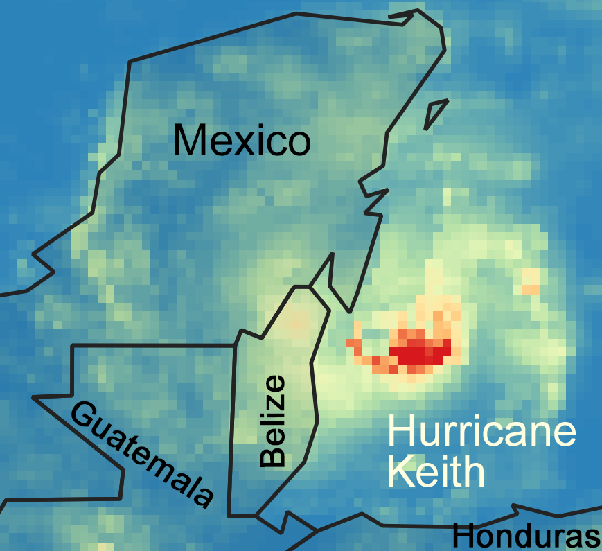
The image above shows the earliest North Atlantic hurricane in the IMERG Version 6 2000-to-present archive, which is Hurricane Keith. Hurricane Keith formed in the Gulf of Mexico and reached category on the Saffir-Simpson scale before making landfall in Mexico. Using the QGIS application, this image was created from the Final IMERG Geographic Information System (GIS) daily product, a 24-hour summary of the 30-minute global 0.1 x 0.1 degree IMERG files. Both the original HDF5 files and these GIS TIFF translations together form the most popular data produce of the GPM mission, based on number of files that researchers download from NASA Precipitation Processing System (PPS).
To learn more about this data product, please read the Algorithm Theoretical Basis Document or visit the Global Precipitation Measurement (GPM) website. Since 2014, George Mason University’s Center for Earth Observing and Spatial Research (COESR0 employees working at NASA’s Precipitation Processing System (PPS) contributed to testing this algorithm and to creating the long-term archive of this algorithm’s output.
References:
NASA, 2019: The Integrated Multi-satelliE Retrievals for GPM (IMERG) Algorithm Theoretical Basis Document. 38 pp. Available online at https://pps.gsfc.nasa.gov/Documents/IMERG_ATBD_V06.pdf.
Kelley, O. 2019: The IMERG multi-satellite precipitation estimates reformatted as 2-byte GeoTIFF files for display in a Geographic Information System(GIS). Available online at https://pps.gsfc.nasa.gov/Documents/README.GIS.pdf.

