Published October 29, 2025
Updated October 31, 2025
Hurricane Melissa Impacts Jamaica
An international constellations of satellites observed Hurricane Melissa as it passed over Jamaica on Tuesday, October 28, 2025.
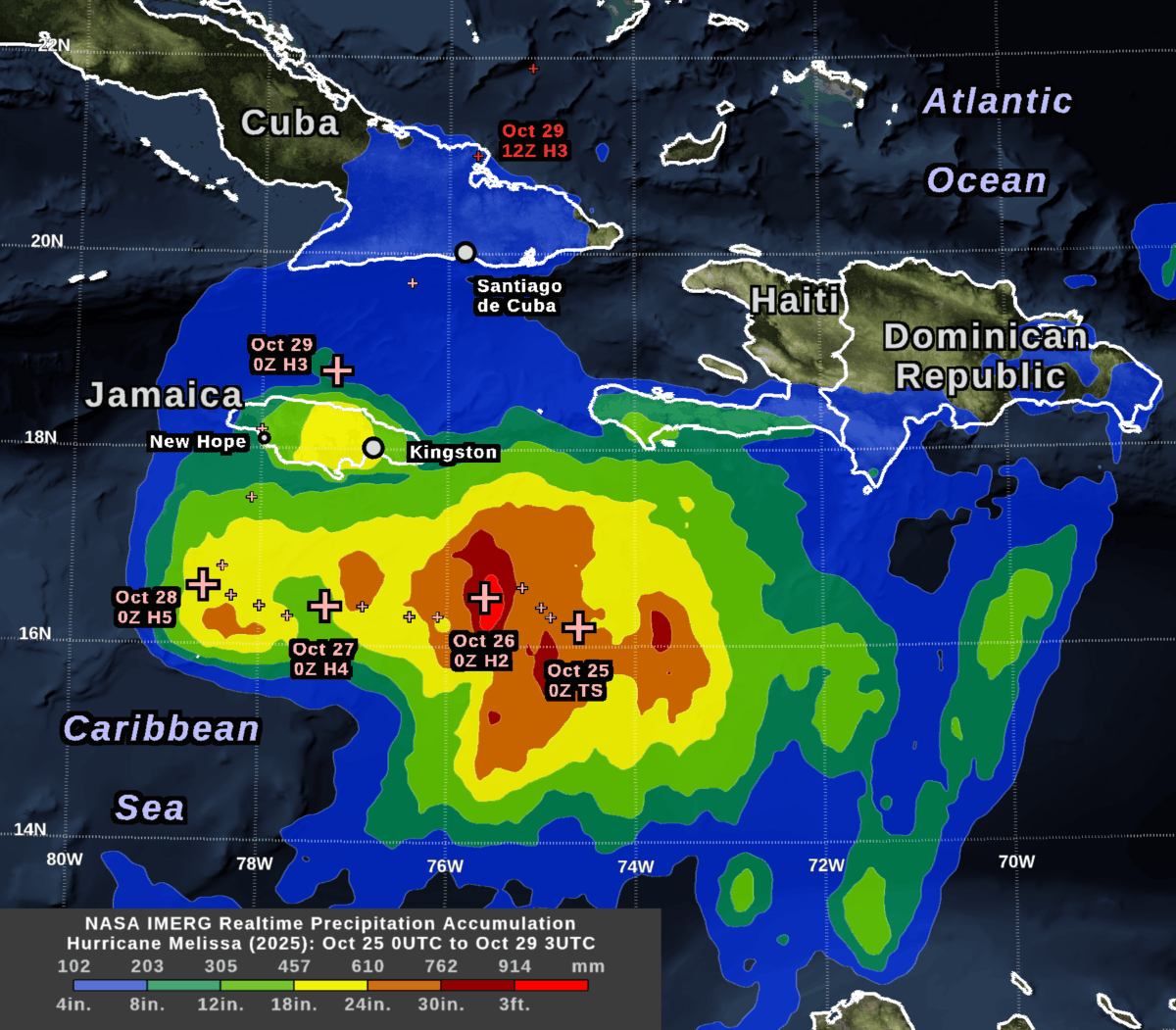
NASA’s IMERG algorithm combined rainfall estimates from these satellites in an effort to create the best possible estimate of rainfall in near real-time. IMERG stands for Integrated Multi-satellitE Retrievals for Global Precipitation Measurement (GPM). The image shows the depth of rain that IMERG estimated over land and sea during a little more than four days: 8PM EST October 24 to 11PM EST October 28 (in universal time, 0000 UTC on the 25th to 0300UTC on the 29th).
A day before landfall, the National Hurricane Center (NHC) forecast that the hurricane would dump 20-30 inches of rain on parts of Jamaica. This large amount of accumulation was expected because the storm was strong (category 5 on the Saffir-Simpson scale), the hurricane’s center was slow moving, and Jamaica has a mountain range oriented perpendicular to the flow of moist, oceanic air that the hurricane would force over the island.
The NHC rainfall forecast turned out to be broadly consistent with the near real-time IMERG estimates that were based on satellite observations.
By examining this storm and other severe weather events, researchers at George Mason’s Center for Earth Observing and Spatial Research (CEOSR) assist the team of scientists who develop the IMERG algorithm. This work is funded by NASA’s Goddard Space Flight Center. It includes helping to test new versions of the algorithm and searching for anomalies in the current version.
IMERG estimated that central Jamaica received 18-24 inches of rainfall during October 26-28, most of which occurred during October 28. This region is the yellow area over central Jamaica in the accumulation image at the top of this post, which can also be downloaded here.
During the preceding 48 hours, the center of Hurricane Melissa had stayed about 100 km south of Jamaica while it strengthened from category 2 to 5 and traveled slowly west. The plus signs in the accumulation image indicate the NHC’s estimate of the location of Hurricane Melissa’s eye every six hours.
The largest rain accumulations during this approximately 3-day-long period were over the ocean southeast of Jamaica, where IMERG estimated over 3 feet of rainfall. In the image at the top of this post, this region is show in bright red. The large accumulation there was caused by a combination of factors, including that rainfall was plentiful as the storm intensified over that location during October 26. Additional rain fell at this location after the hurricane eye had moved west because of a persistent precipitation feature that tracked to the east of the hurricane’s eye.

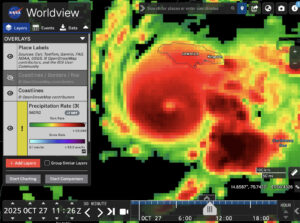
Snapshot of the IMERG rainfall rate estimate for Hurricane Melissa during 7:00-7:30 AM EDT on October 27, 2025 (1100-1130 UTC) .
In the image above, this persistent stormy area east of Melissa is indicated with the arrow in the 30-minute precipitation-rate image. This image was captured from NASA’s Worldview web page. This image shows data from 16 hours before Melissa made landfall in Jamaica at approximately 1PM EDT (1700 UTC on October 28) according to the National Hurricane Center. You can view a higher resolution version of this image here or interactively explore this data by following this link to Worldview.
Melissa Before and After Impacting Jamaica
The evolution of Melissa’s rainfall pattern can be tracked with the estimates available every 30 minutes from the IMERG algorithm. These estimates cover the globe with a resolution of approximately 7 miles (i.e., each grid box covers 0.1 degrees of latitude and longitude).
For October 23 through 29, the animation below shows heavy rainfall in dark red and cloud cover in shades of gray.
Animation of rainfall from Hurricane Melissa during October 23-29, 2025, as estimated by the IMERG algorithm.
On October 23, Melissa was a tropical storm southeast of Jamaica with sustained heavy rainfall in excess of 25 mm/hr. Smaller areas of heavy rainfall persisted after Melissa passed over Jamaica on October 28. They were mostly absent after Melissa traveled north of Cuba the next day.
At the end of the movie, the rain rates are hidden and the total 7-day rainfall accumulation is show in a green-purple color table. Despite the relatively lower rain rates over Cuba, total accumulations over eastern Cuba were still estimated to exceed 11.8 inches (300 mm) in some locations by the end of the day on October 29. These areas are shown in light purple. Accumulations in excess of 19.7 inches (500 mm) are shown in dark purple, and include large areas of the Caribbean Sea as well as central Jamaica.
When no satellite observations are available for a particular location and half-hour period, IMERG morphs satellite-observed precipitation from earlier or later times along the direction of the prevailing winds.
IMERG is ideal for monitoring hurricanes and other weather events that travel over land and ocean. Rainfall forecasts are available over the whole globe, but there are no rain gauges or weather radars nearby over the great majority of the ocean, so it is difficult to estimate how much rain actually falls there. Even over land areas with rain gauges, these measurements may not be available immediately after a storm strikes when disaster response must be organized.
For More Information
For more information about the IMERG algorithm, visit the website of NASA’s Global Precipitation Measurement (GPM) Mission. The Precipitation Processing System (PPS) at NASA Goddard runs the IMERG algorithm and distributes the data products.
Credits: Animation created by Jason West (KBR). Images created by Owen Kelley (GMU). Caption by Owen Kelley and Jason West.

