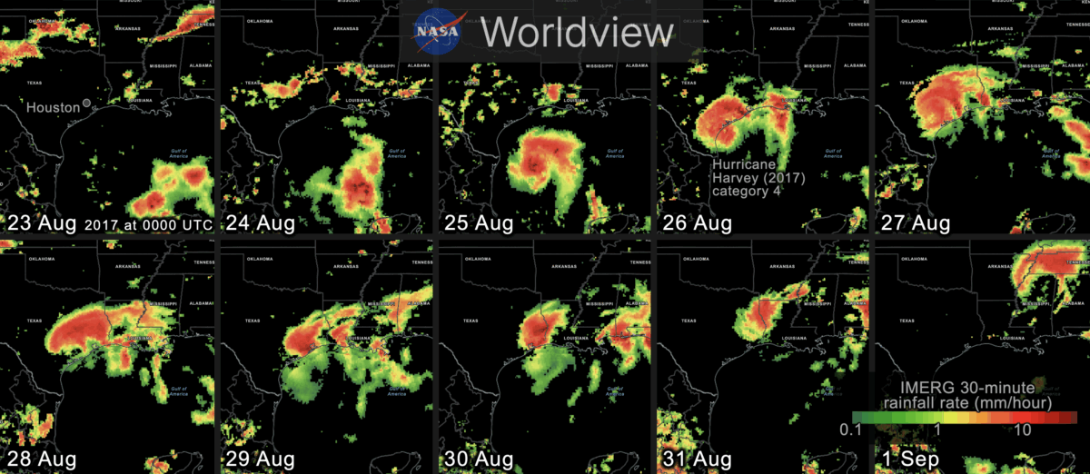
CEOSR personnel working at NASA’s Precipitation Processing System (PPS) have generated 27 years of global rainfall imagery that is now available in NASA Worldview, which is NASA’s online archive of Earth science imagery.
NASA’s Worldview website now allows you to explore global estimates of rainfall and snowfall from 1998 to the present at 30-minute intervals. Researchers and application developers have been using this dataset since 2014 (Portier 2024; Portier et al. 2023), but now it is also available as images in Worldview.
This precipitation dataset is called IMERG, which stands for Integrated Multi-satellitE Retrievals for Global precipitation measurement (GPM). Over the years, a team of NASA scientists have improved the IMERG algorithm’s accuracy over land and ocean (Huffman et al. 2023a,b,c).
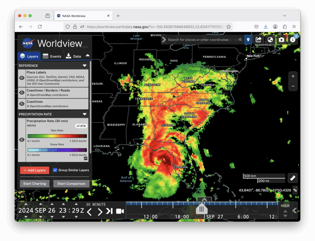
Worldview is now being updated every hour with the most recent global IMERG estimates. Worldview is a user-friendly website for visualizing many of NASA’s Earth science datasets. The image below shows the precipitation falling from Hurricane Helene shortly before it made landfall in Florida in September 2024 (West et al. 2024). In the image, you can see how the IMERG estimates cover land and also ocean where there are no rain gauges or ground radars.

NASA runs the IMERG algorithm three times for each 30-minute period. The precipitation estimates from the first run become available just 5 hours after satellite observations are made, and that run is called Early IMERG. This near real-time dataset is useful for forecasting floods and monitoring large storm systems. A second run, called Late IMERG, occurs about 15 hours after observations are made. About four months later, the IMERG algorithm is run one last time when more observations and calibration datasets are available as inputs. This last run is called Final IMERG. Final IMERG is useful for studying droughts and other seasonal deviations from normal conditions. It can also be used for post-season reexamination of major events such as hurricanes. The Worldview website displays Final IMERG when available and Early IMERG otherwise.
Worldview for Beginners
If you haven’t used NASA’s Worldview website before, it is easy to learn how. Start by visiting https://worldview.earthdata.nasa.gov. There is no App to download, no user registration, and no charge.
When you visit Worldview, it initially loads satellite imagery of the most recent observations of the Earth’s surface and clouds. Precipitation is not initially displayed.
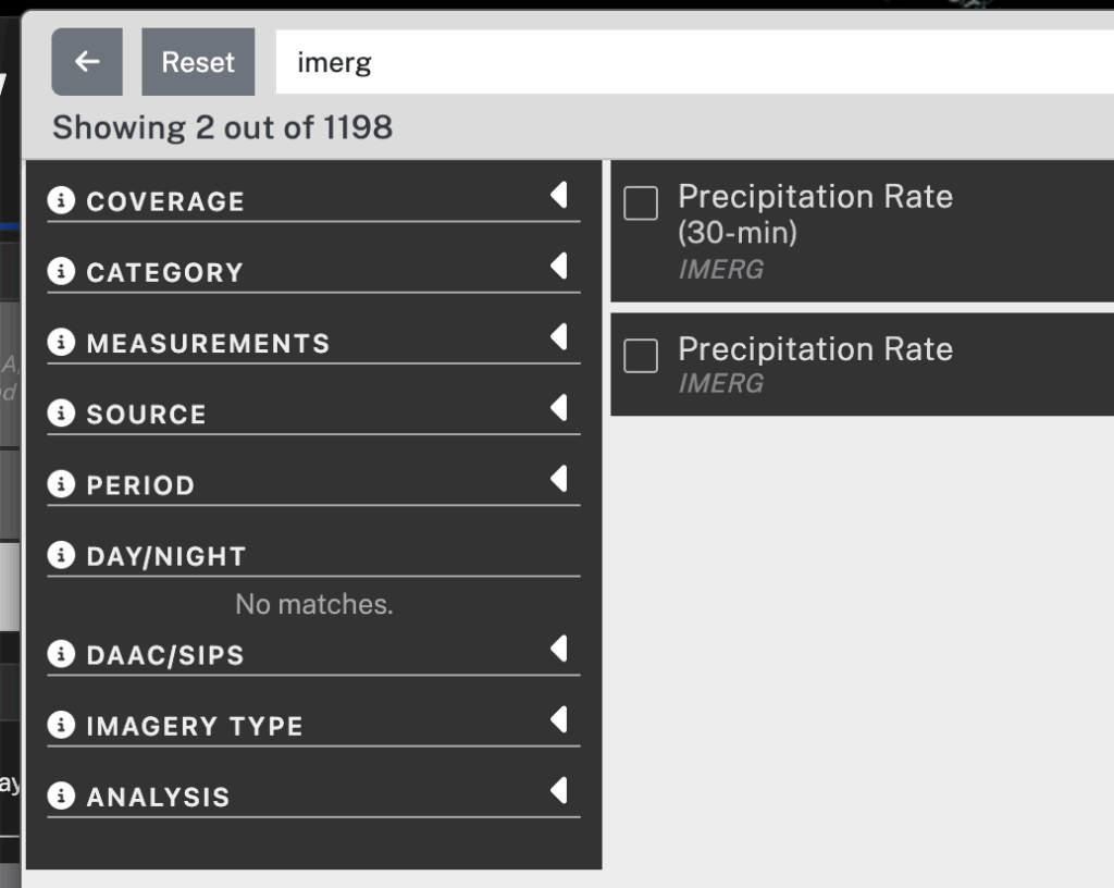
It takes two steps to display IMERG precipitation in Worldview. The first step is to add to your session the Worldview layer that contains 30-minute IMERG precipitation estimates. To do so, click the Add Layer button in the lower left corner. In the panel that pops up, type “imerg” in the search field. In the search results, check the box next to the entry for 30-minute IMERG. To dismiss the Add Layer panel, click the “X” symbol in the upper right.

The second step is to move a few hours into the past. To do so, you can move the time slider a little to the left in the timeline along the bottom of the Worldview window. Alternatively, you can use the arrow icons to move the clock display back a few hours. This time adjustment is necessary because IMERG precipitation estimates are created approximately 5 hours after satellite observations are made and it takes another hour or so to convert the data into Worldview imagery.

The 30-minute IMERG imagery should now be visible with green-yellow-red colors for rainfall estimates and cyan-blue-purple colors for snowfall estimates. To adjust the map’s zoom level, use the plus and minus buttons in the Worldview window or the scroll wheel on your mouse if you have one. To change the map’s location, drag the map with your mouse. By default, Worldview shows coastlines. For more detailed political boundaries and place labels, turn on optional layers. These optional layers can be found at the top of the layer list on the left side of Worldview.
The IMERG algorithm estimates the precipitation rate at the middle of each 30-minute period, i.e., 15 minute and 45 minute after the hour. The units of precipitation rate are the millimeters of rain-equivalent depth that would accumulate in an hour if the observed precipitation rate (rainfall or snowfall) were to persist for a full hour. If the precipitation is frozen, then the value that IMERG reports is the depth of liquid water that would result if the frozen precipitation were melted before its depth is measured. The liquid-equivalent depth of snowfall is relevant to the water storage in snowpack, which influences how much water will become available to plants once the snow melts. Because fresh snow contains air (i.e., it’s fluffy), about 4 to 20 inches of snowfall will melt down to just an inch of liquid water (Baxter et al. 2005). IMERG states the liquid-equivalent depth of snowfall, but most weather reports state the depth of snowfall in its original, frozen form.
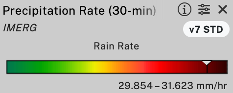
One advantage to viewing IMERG precipitation imagery within Worldview is that one can hover over an image in Worldview to obtain a numerical range for the precipitation rate represented by that pixel of the image. The numerical range is displayed in the color bar on the left side of the browser window. This color-table-interrogation feature is available only if you are using a device with a mouse that can hover, such as a laptop or desktop but not a mobile device.

If you encounter any trouble downloading IMERG data, contact the GPM project using the contact page.
Credits: Story and visualization by Owen Kelley.
References
Baxter et al., 2005: A Climatology of Snow-to-Liquid Ratio for the Contiguous United States. Weather and Forestcasting, 20, 729–744, Figs. 3 and 5.
Huffman, G. J., D. T. Bolvin, D. Braithwaite, K. Hsu, R. Joyce, C. Kidd, E. J. Nelkin, S. Sorooshian, J. Tan, and P. Xie, 2023a: NASA Global Precipitation Measurement (GPM) Integrated Multi-satellitE Retrievals for GPM (IMERG) Version 07, Algorithm Theoretical Basis Document (ATBD). https://arthurhou.pps.eosdis.nasa.gov/Documents/IMERG_V07_ATBD_final.pdf.
Huffman, G. J., D. T. Bolvin, R. Joyce, O. A. Kelley, E. J. Nelkin, J. Tan, D. C. Watters, and B. J. West, 2023b: Integrated Multi-satellitE Retrievals for GPM (IMERG) Technical Documentation. white paper, https://arthurhou.pps.eosdis.nasa.gov/Documents/IMERG_TechnicalDocumentation_final.pdf.
Huffman, G. J., D. T. Bolvin, R. Joyce, O. A. Kelley, E. J. Nelkin, J. Tan, D. C. Watters, and B. J. West, 2023c: IMERG V07 Release Notes. white paper, https://arthurhou.pps.eosdis.nasa.gov/Documents/IMERG_V07_ReleaseNotes_final.pdf.
Portier, A., 2024: Using GPM Precipitation Data to Help Inform Decisions and Policies Throughout the Globe. GPM 10-in-10 Webinary Series: Application, NASA, https://www.youtube.com/watch?v=NPg_2H-XxR4.
Portier, A., D. Kirschbaum, M. Gebremichael, E. Kemp, S. Kumar, I. Llabres, E. Snodgrass, and J. Wegiel, 2023: NASA’s Global Precipitation Measurement Mission: Leveraging Stakeholder Engagement & Applications Activities to Inform Decision-making. Remote Sensing Applications: Society and Environment, https://doi.org/10.1016/j.rsase.2022.100853.
West, J., S. Lang, and J. Reed, 2024: Powerful Hurricane Helene Makes Landfall in Florida’s Big Bend. GPM website, https://gpm.nasa.gov/applications/weather/news/powerful-hurricane-helene-makes-landfall-floridas-big-bend.

